By using the Social Pinpoint Mapping Tool you are taken to have accepted these Terms and Conditions set out below.
This crowdsourced map is being used by the California State Parks for project purposes only. While input submitted via the map will be reviewed in aggregate and inform State Parks' work efforts, staff will not be responding directly to individual comments.
For a direct response to a comment or issue, please contact Gabriela Polo (gabriela.polo@coastal-quest.org) or Darren Smith (darren.smith@parks.ca.gov) and we will get back to you as soon as possible. Thank you.
California State Parks San Diego Coast District Sea Level Rise Plan
Welcome! | ¡Bienvenidos!
We need your help identifying places and features of coastal state parks in San Diego that are most important to you.
Provide your perspective on how you currently use and what you value about coastal parks. For example, share what you value about the trails you walk and bike, beaches you swim and sightsee, and parks where you spend time with yourself and loved ones. Is there a particular spot or activity that you enjoy? Is there an access point to a park that you think should be maintained under future rising sea levels?
Please share your ideas for making our state parks even better as we address sea level rise and other climate change effects and help ensure the enjoyment of coastal parks for generations to come.
On the sidebar on the left of the screen, select which coastal state park(s) you would like to provide a comment. On the map, click “Add comment”, drop the marker at the location, select the appropriate icon, and provide any additional notes. On a wide-screen monitor, you can choose a category from the top of the screen and drag the icon onto the map to leave a comment. The more specific the comment, the better. Additional instructions for providing comments can be found at this short, helpful video.
If you prefer to leave a general comment about the types of things you like to do when you go to the beach or coastal parks, you can leave a comment in the "Share a general comment!" tab on the sidebar on the left of the screen.
Necesitamos su ayuda para identificar los lugares y las características de los parques estatales costeros de San Diego que son más importantes para usted.
Proporcione su perspectiva sobre cómo usa actualmente y qué valora de los parques costeros. Por ejemplo, comparta lo que valora de los senderos por los que camina y pasea en bicicleta, las playas en las que nada y recorre, los parques donde usted y sus seres queridos pasan tiempo. ¿Hay algún lugar o actividad en particular que disfrute? ¿Hay un punto de acceso a un parque que usted cree que debería mantenerse seguro bajo el futuro aumento del nivel del mar?
Comparta sus ideas para mejorar aún más nuestros parques estatales a medida que lidiamos con el aumento del nivel del mar y otros efectos del cambio climático, y ayúdenos a garantizar que las generaciones venideras puedan seguir disfrutando de los parques costeros.
En la barra lateral a la izquierda de la pantalla, seleccione de qué parque(s) costero(s) estatal(es) le gustaría proporcionar un comentario. En el mapa, haga click en "Agregar comentario", coloque el marcador en la ubicación, seleccione el ícono apropiado y proporcione cualquier nota adicional. En un monitor de pantalla ancha, puede elegir una categoría desde la parte superior de la pantalla y arrastrar el icono al mapa para dejar un comentario. Cuanto más específico sea el comentario, mejor. Puede encontrar instrucciones adicionales para proporcionar comentarios en este breve y útil video.
Si prefiere dejar un comentario general sobre el tipo de cosas que le gusta hacer cuando va a la playa o los parques costeros, puede dejar un comentario en la sección "¡Comparte un comentario general!" de la barra lateral a la izquierda de la pantalla.
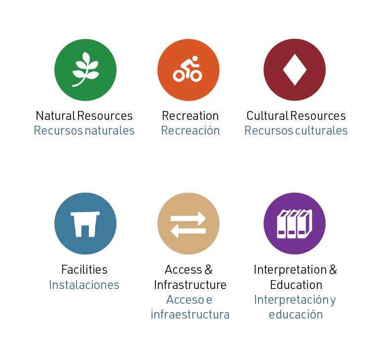
Share your comments using the following marker types:
- Natural Resources (green leaf marker): For comments related to land cover such as beaches and dunes, as well as vegetation, landscaping, and more.
- Recreation (orange bike marker): For comments about how and where you recreate inside the parks, including camping, picnicking, watersports, and more.
- Cultural Resources (red diamond marker): For comments about historic buildings, cultural resources, and more.
- Facilities (blue building marker): For comments about the facilities you use, including bathrooms, visitor centers, event spaces, and more.
- Access and Infrastructure (tan arrows marker): For comments about parking areas, roads, bike paths, ADA access points, trails, staircases, and more.
- Interpretation and Education (purple books marker): Share comments about programs, events, or interpretive trails and signage.
Comparta sus comentarios utilizando los siguientes tipos de marcadores:
- Recursos naturales (marcador de hoja verde): para comentarios relacionados con la cobertura del suelo, como playas y dunas, así como vegetación, paisajismo y más.
- Recreación (marcador de bicicleta naranja): para comentarios sobre cómo y dónde pasa tiempo dentro de los parques, incluidos campamentos, picnics, deportes acuáticos y más.
- Recursos culturales (marcador de diamante rojo): para comentarios sobre edificios históricos, recursos culturales y más.
- Instalaciones (marcador de edificio azul): para comentarios sobre las instalaciones que utiliza, incluidos baños, centros de visitantes, espacios para eventos y más.
- Acceso e infraestructura (marcador de flechas color canela): Para comentarios sobre áreas de estacionamiento, caminos, ciclovías, puntos de acceso ADA, senderos, escaleras y más.
- Interpretación y Educación (marcador de libros morados): Comparta comentarios sobre programas, eventos o senderos interpretativos y señalización.
Layers | Capas

Using the "Layers" button at the top right-hand side of the map will allow you to toggle the following layers on and off:
- Permanent Inundation (1.6 feet) (dark blue boundaries)
- 100-Year Storm Surge Flooding (1.6 feet) (light blue boundaries)
El uso del botón "Capas" en la parte superior derecha del mapa le permitirá activar y desactivar las siguientes capas:
• Inundación permanente (1.6 pies) (límites azul oscuro)
• Inundaciones por marejadas ciclónicas de 100 años (1.6 pies) (límites azul claro)
Please visit bit.ly/SDSLRinfo if you want to stay involved and receive updates about our work. You can sign up for future mailings on the website and find information about the State Parks' upcoming projects and community events.
Together, let’s create climate-resilient and enjoyable state parks for everyone.
Por favor visite bit.ly/SDSLRinfo si desea seguir involucrado y recibir actualizaciones sobre nuestro trabajo. Puede suscribirse para recibir futuros correos en el sitio web y encontrar información sobre los próximos proyectos y eventos comunitarios de State Parks.
Juntos, vamos a crear parques estatales resilientes al cambio climático y que todos podamos disfrutar.